Is There Mobile Network at Adi Kailash? Connectivity, Safety and Emergency Prep
Every family member waiting at home wants to know one thing: will you be reachable? Every trekker heading to Adi Kailash wonders the same thing in reverse: can I call for help if something goes wrong? The question of adi kailash mobile network coverage seems simple. The answer is not. The honest truth is that mobile connectivity on the Adi Kailash route is patchy at best and completely absent at worst — and the sections where it disappears entirely happen to be the most remote, most high-altitude, and most critical stretches of the journey. This guide gives you the exact signal reality checkpoint by checkpoint, tells you which SIM gives the best chance of connectivity, and — far more importantly — tells you what to do when there is no signal at all and something goes wrong.
The Honest Reality of Adi Kailash Mobile Network Coverage
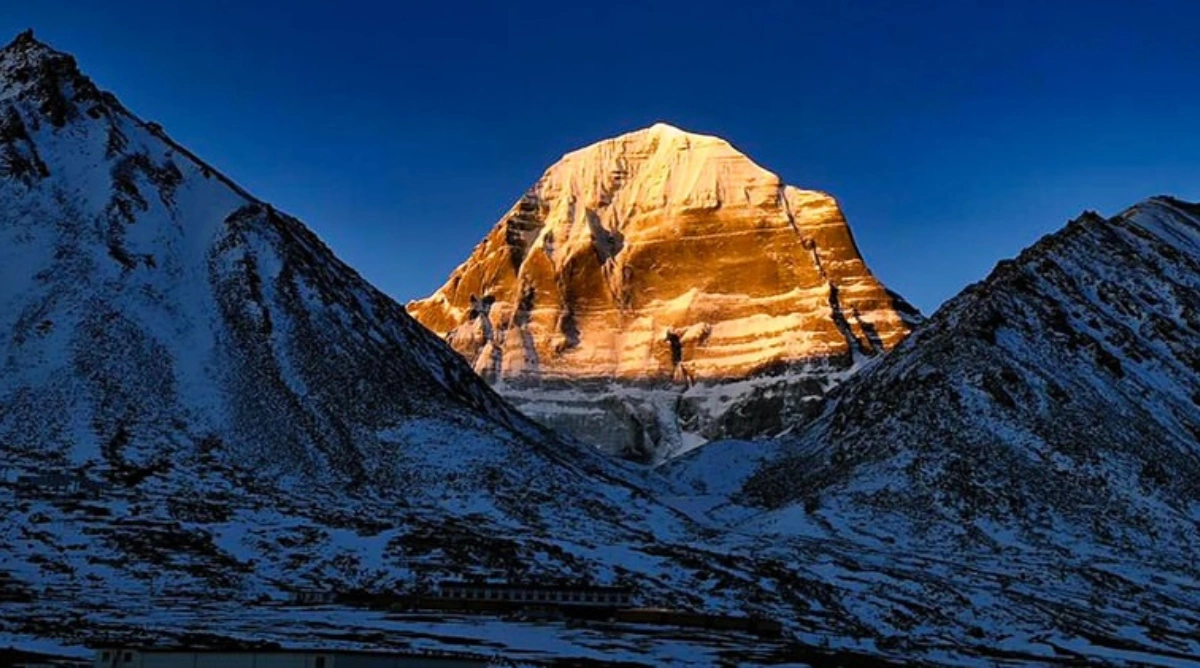
The Adi Kailash route runs through the Pithoragarh district of Uttarakhand, deep into a restricted Indo-Tibetan border zone. This is not a developed trekking corridor like Kedarnath or the Valley of Flowers. It is a high-security, high-altitude border area where civilian infrastructure — including telecom towers — is minimal by design. The further you travel from Dharchula, the less the adi kailash mobile network functions. At some points on the route, it stops functioning entirely. No amount of checking your phone, switching flight mode on and off, or climbing a small hill to 'find signal' will change that. Accepting this reality before you leave is the first and most important step in preparing for it.
Signal Reality: Checkpoint by Checkpoint
| Location | Network |
| Dharchula (915 m) | Good |
| Tawaghat / Malpa (~1,100 m) | Weak |
| Budhi / Nabi (~2,000 m) | Very Weak |
| Gunji (~3,325 m) | Occasional Signal |
| Nabhidhang (~3,600 m) | Rare Signal |
| Kuti Village (~3,720 m) | No Signal |
| Jolingkong / Adi Kailash Base (~4,420 m) | No Signal |
| Gauri Kund / Parvati Kund (~4,500 m+) | No Signal |
The pattern is clear and consistent with every trekker report from the route: Dharchula is your last reliable point of connectivity. Beyond that, BSNL may offer occasional weak signals at Gunji and Nabhidhang — but these are not dependable enough to plan around. At the sacred sites themselves, you are completely off-grid.
Which SIM Works Best on the Adi Kailash Route?
If you are planning to carry a working phone for the sections of the route where some signal is possible, your SIM choice matters significantly.
BSNL: The Only Viable Option Beyond Dharchula
BSNL is the clear answer for adi kailash mobile network coverage on this route. As a government-owned operator with infrastructure specifically built for border and rural regions, BSNL consistently outperforms private operators in areas like Gunji and Nabhidhang where any signal exists at all. In September 2025, BSNL also completed the nationwide launch of its swadeshi 4G network, commissioned more than 97,500 towers, and specifically prioritised coverage in border areas, hilly terrain, and Jammu and Kashmir — a rollout that is gradually improving signal in remote Uttarakhand too.
- Carry a BSNL SIM card as your primary device for this trek — prepaid SIMs are widely available in Pithoragarh and Dharchula
- Recharge your BSNL SIM fully before leaving Dharchula — there are no top-up options beyond this point
- Make sure your phone is unlocked or that you have a dual-SIM device allowing both your home SIM and a BSNL SIM
Jio, Airtel, and Vi: Effective Only in Dharchula and Below
Private telecom operators including Jio, Airtel, and Vodafone-Idea (Vi) have reasonable coverage in Dharchula and the Pithoragarh town area. However, their signal disappears rapidly once you move into the restricted border zone beyond Tawaghat. Do not rely on these networks for anything beyond Dharchula. Use your last hours in the town to make all important calls, send updates to family, download offline content, and back up your phone while private network coverage is still available.
Why There Is No Mobile Network at Higher Altitudes
Understanding why the adi kailash mobile network fails beyond a certain point helps you plan more realistically — and stops you from spending precious energy trying to find a signal that simply does not exist.
The Border Zone Factor
The Adi Kailash route runs through the restricted Indo-Tibetan Border Zone, directly adjacent to the Line of Actual Control (LAC) between India and China. This area falls under the direct jurisdiction of the Indo-Tibetan Border Police (ITBP). Civilian telecom infrastructure is minimal in these zones for security and logistical reasons — civilian mobile towers near active border areas require significant government clearance and long deployment timelines.
The Terrain and Altitude Factor
Even where civilian towers exist, high-altitude Himalayan terrain creates formidable signal propagation challenges. Towers in Dharchula or Pithoragarh are simply too far away and too topographically obstructed to provide meaningful coverage at 3,500 metres and beyond in the Vyas Valley. The deep gorges, ridge lines, and sheer elevation changes create natural signal black zones that no amount of tower installation in the current geography fully resolves.
The ITBP Communication Infrastructure
The ITBP maintains its own dedicated communication network throughout the border zones where the Adi Kailash route runs. This network operates independently of civilian telecom infrastructure and is not accessible to civilian trekkers or pilgrims. However, the presence of ITBP checkposts along the route — at Gunji and other key points — means that in a genuine emergency, ITBP personnel can relay communications through their own channels. This is one of the reasons why staying registered with ITBP checkposts along the route is important, not just a bureaucratic requirement.
What to Do Before You Lose Signal: The Pre-Departure Connectivity Checklist
Dharchula is your last guaranteed point of full connectivity. The actions you take in Dharchula — and in the days before you leave home — directly determine how safe and how connected you remain for the rest of the journey. Do not rush this preparation.
Before Leaving Home
In Dharchula — Your Last Connected Checkpoint
- Make all important calls to family and emergency contacts while you still have reliable signal
- Send your exact itinerary via message or email so your family has it in writing
- Top up your BSNL SIM fully — there is nowhere to top up beyond this town
- Download offline maps for the specific route segments beyond Gunji
- Back up your phone to cloud storage while on Wi-Fi — photos, documents, contacts
- Download any medical information, trek guides, or emergency protocol documents you may need access to offline
- Confirm your operator's satellite or radio communication equipment is functional and being carried
- Check your satellite communicator battery and charging cables if you are carrying one
Emergency Protocols If Something Goes Wrong Without Signal
This section is the most important part of this guide. Being prepared for an emergency without mobile connectivity requires advance planning, not improvisation on the trail.
Medical Emergencies
- Your first line of communication in any medical emergency is your trek guide — a trained, experienced guide is your most critical safety asset on this route
- Reputable tour operators carry first-aid kits, portable oxygen cylinders, and pulse oximeters — confirm these are included before booking your package
- Satellite communicator SOS: if available, activating SOS connects to international rescue coordination who then contact Indian agencies — this is the fastest way to summon external help from beyond Gunji
- ITBP checkposts at Gunji and other points along the route can relay emergency communication through their own secure channels — in a genuine emergency, approach any ITBP post directly
- Descent is the first and most effective treatment for altitude-related emergencies — guides are trained on this protocol and should be empowered to initiate descent without waiting for outside instruction
Getting Lost or Separated From the Group
- Never trek alone beyond Gunji — the terrain, altitude, and complete absence of mobile network make solo trekking genuinely dangerous
- Carry a physical map and compass or a GPS device with offline maps loaded — do not rely solely on your phone's online mapping
- Agree on a group meeting point at every major trail junction before the day's walking begins
- Carry a whistle — three short blasts is the international distress signal on mountain trails
- Stay put if you are genuinely lost and wait for your group or guide to return — moving without knowing your position in this terrain makes rescue more difficult
Emergency Contact Numbers to Save Before Leaving Dharchula
- Dharchula SDM Office: Keep this number saved — they coordinate administrative emergency responses in the border zone
- ITBP Dharchula Sector Headquarters: The Indo-Tibetan Border Police is the primary emergency authority along this route
- Pithoragarh District Emergency: Save the Pithoragarh district administration emergency number
- Your tour operator's 24-hour emergency contact: A reputable operator will provide this — if yours does not, that is a red flag
- State Disaster Response Force (SDRF) Uttarakhand: The state's dedicated mountain rescue unit
Write all of these numbers on a physical piece of paper and carry it in your jacket pocket — not just in your phone. If your phone runs out of battery or is damaged, you still need access to these contacts.
How to Manage Your Phone Battery Without Connectivity
Even without mobile signal, your phone remains one of your most useful tools on the Adi Kailash route — as a camera, offline map viewer, torch, altitude tracker, and data storage device. Battery management becomes critical when you cannot rely on consistent charging infrastructure.
- Carry a high-capacity power bank — minimum 20,000 mAh for a multi-day trek without reliable charging access; 30,000 mAh for a full 8 to 10 day yatra
- Enable aeroplane mode beyond Dharchula: your phone burns battery rapidly searching for a signal that does not exist — aeroplane mode eliminates this drain
- Turn off location services, push notifications, and background app refresh to further extend battery life
- Keep your phone warm at altitude: battery performance drops significantly in cold temperatures — carry your phone inside your jacket rather than in your outer pocket
- Charging facilities in Gunji are basic and power supply is unreliable — charge your power banks fully in Dharchula
- Consider a small solar charging panel if your trek extends across multiple days at high altitude where no power is available
Why Your Choice of Operator Matters for Safety Without Signal
On a route where adi kailash mobile network coverage is this limited, your tour operator becomes your single most important safety system. The right operator does not just plan your itinerary — they are your communication line, your medical support, your emergency contact, and your evacuation coordinator when your phone is useless.
What a Safety-Conscious Operator Provides
- Walkie-talkie or radio communication between guides and the support team at the base — essential for real-time communication when phones are dead
- Satellite communication device carried by the lead guide — so emergency SOS can be sent from anywhere on the route
- A dedicated emergency contact number that family members can reach 24 hours a day throughout the yatra
- Pre-arranged emergency evacuation protocols with ITBP and local mountain authorities
- Portable oxygen cylinders, first aid kits, and a guide trained in wilderness first aid
- A clear, written emergency protocol shared with pilgrims before the trek begins
When enquiring about or booking an Adi Kailash package, ask your operator directly: what communication equipment does your guide carry beyond Gunji? What is your emergency evacuation protocol? What is your 24-hour emergency contact for families? The answers tell you immediately whether this is an operator who takes safety seriously or one who considers it an afterthought.
Conclusion
The honest answer about adi kailash mobile network coverage is this: plan as if there is no network beyond Dharchula, and you will be prepared for the reality of the route. BSNL may give you a brief signal at Gunji. It may not. Either way, your safety on this journey must not depend on it. The Adi Kailash route is one of the most spiritually powerful and physically remote journeys in India. The silence of no signal — for many pilgrims — becomes part of the experience. The modern world falls away. The mountain takes over. But arriving at that silence prepared, with your family informed, your satellite device charged, your offline maps downloaded, and your operator carrying communication equipment — that is what separates a meaningful journey from a dangerous one. Go prepared. Go connected where you can. And surrender the rest to the mountain.