Tungnath Trek Distance Guide: Accurate KM, Altitude & Trek Time
Here is something that happens to almost every first-time Tungnath trekker. You search online for the
trek distance, you get five different answers — 3 km, 4 km, 6 km, sometimes even 8 km — and you end
up more confused than when you started. You show up at Chopta either completely underprepared or
carrying gear for a three-day expedition when all you needed was a daypack and a good pair of shoes.
The confusion usually comes from the fact that some sources count only the Chopta to Tungnath
Temple section, while others include the extension to Chandrashila Peak. Some do not mention that
Chopta is the actual tungnath trek starting point at all. This guide puts all of that to rest. You will find the
exact tungnath trek distance at every stage — from Chopta to the temple, from the temple to
Chandrashila, the full round trip, the altitude gain, the time it takes, and everything in between. Read this
once and you will be ready
Tungnath Trek Distance: The Numbers You Actually Need
Let us get straight to it. The tungnath trek distance from Chopta to the Tungnath Temple is 3.5 km one
way. On the way back, it is the same 3.5 km — so the basic round trip is about 7 km. That sounds short,
and on flat ground it would be. But this trail climbs 1,000 metres of altitude in those 3.5 km. That is what
makes it feel longer than the number suggests, and that is what makes it genuinely rewarding.
Now, if you are planning to push on to Chandrashila Peak — which you absolutely should if your legs
allow it — add another 1.5 km each way beyond the temple. The full loop from Chopta, up to
Chandrashila, and back to Chopta covers approximately 10 km. Most trekkers who start early do this
comfortably in a single day and are back at Chopta for a hot meal by late afternoon.
Tungnath Trekking Distance: Stage-by-Stage at a Glance
Before we walk through each section in detail, here is the complete stage-by-stage breakdown of the
tungnath trekking km so you can see the whole picture at once. Pin this in your memory before you lace
up your boots.
| Stage | Section | Distance | Time |
|---|
| 1 | Chopta → Forest Entry | ~1 km | 20–25 min |
| 2 | Forest → Tungnath | ~2.5 km | 1.5–2 hrs |
| 3 | Tungnath → Chandrashila | ~1.5 km | 45–60 min |
| Return | Chandrashila → Chopta | ~5 km | 1.5–2 hrs |
| Total | Round Trip | ~10 km | 6–8 hrs |
Tungnath Trek Starting Point: Getting to Know Chopta
Chopta is the kind of place that makes you wonder why you waited so long to visit. It is a small cluster of
lodges and dhabas sitting inside the Kedarnath Wildlife Sanctuary at 2,680 metres, surrounded by open
meadows that look out at some of the most jaw-dropping Himalayan scenery in Uttarakhand. Locals call
it the 'Mini Switzerland of India' — and once you see those rolling meadows against the snow-capped
backdrop of Kedarnath, Nanda Devi, and Chaukhamba, you will understand why.
The tungnath trek starting point is right here — a clearly marked stone-paved trailhead rising from the
Chopta meadow into a dense rhododendron and oak forest. You literally step off the road and start
walking uphill. There are tea stalls at the base, pony operators if you need them, and local guides ready
to go. The entire place has a wonderfully unhurried, pilgrimage-town atmosphere.
How to Reach Chopta
- From Delhi: 450 km via Rishikesh, Devprayag, Rudraprayag, Ukhimath, and Dugalbitta. Allow 12 to
14 hours by road.
- From Dehradun: 235 km via Rishikesh and Rudraprayag. Approximately 7 to 8 hours by car.
- From Rishikesh: 209 km. The most popular jumping-off point — cabs and shared jeeps run
regularly to Ukhimath from where local transport continues to Chopta.
- Nearest airport: Jolly Grant Airport, Dehradun (approximately 245 km). Hire a cab from the airport
to Chopta.
- No single direct bus runs to Chopta from major cities — most travellers take a bus to Ukhimath or
Rudraprayag and switch to a local cab for the final stretch to Chopta.
Walking the Trail: Every Stage of the Tungnath Trek
Stage 1 — Chopta Meadow to Forest Entry: The Warm-Up (1 km)
The first kilometre is the friendliest part of the day. The trail begins flat and open across the Chopta
meadow, giving you sweeping views of the surrounding hills before you even start to climb. There is a
small entry gate where you may need to show ID. Beyond it, the trail enters the rhododendron forest
and the real journey begins. Use this section to find your pace, settle your breathing, and remind
yourself — it is not a race. The mountain will be there when you arrive.
Stage 2 — Forest Climb to Tungnath Temple: The Heart of the Trek (2.5 km)
This is where the tungnath trekking distance earns its reputation. Once inside the forest, the trail turns
sharply uphill and stays that way. Stone steps cut into the hillside make the path secure, but the
gradient demands steady effort. The rhododendrons here are extraordinary — in April and May, the
forest blazes with red and pink blooms that frame every turn in the trail. Higher up, the trees thin out and
the world opens up into high-altitude meadows. The first time you step out of the treeline and see the
Himalayan peaks rolling out in front of you — Kedarnath, Nanda Devi, Chaukhamba — is a moment you
will carry with you for a long time.
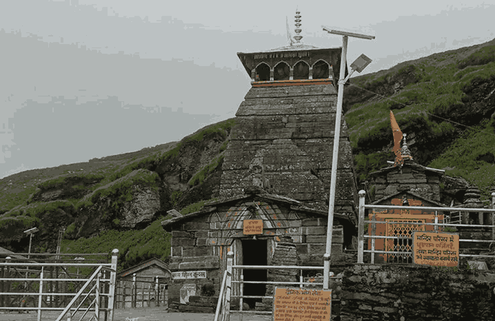
The Tungnath Temple appears at the top of this climb, sitting at 3,680 m with an ancient, quietly
powerful presence. It is the highest Shiva temple in the world — and standing at its doorstep after
climbing 1,000 metres from Chopta, that feels entirely right. Take your time here. Have tea at one of the
small dhabas, offer your prayers, eat something warm, and let the altitude settle before deciding
whether to push on to Chandrashila.
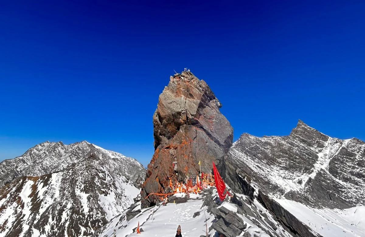
Stage 3 — Tungnath Temple to Chandrashila Summit: The Finale (1.5 km)
The tungnath to chandrashila distance of 1.5 km from the temple to the summit looks manageable on
paper. In practice, it is the steepest 1.5 km of the day. The trail leaves the temple behind, climbs through
rocky open grassland with no tree cover, and gains 450 metres in altitude quickly. There is no shade,
the air is noticeably thinner, and if there is any wind it will find you here. But when you pull yourself over
that final ridge and the Chandrashila summit opens up in front of you — every burning muscle
disappears.
The 360-degree view from 4,130 m is extraordinary. Nanda Devi (7,816 m), Trishul (7,120 m),
Kedarnath Peak (6,940 m), Bandarpunch, Chaukhamba — the full Garhwal Himalayan arc laid out like a
panorama painted by someone who was showing off. There is a small temple at the summit dedicated
to Lord Shiva and Lord Rama. The descent from Chandrashila back to the Tungnath Temple takes 30 to
45 minutes, and from the temple back to Chopta another 1 to 1.5 hours — much easier on the way
down.
Tungnath Trek Height: Understanding the Altitude Before You Go
The tungnath trek height profile is something every trekker needs to understand clearly — not to be
alarmed, but to be prepared. Chopta starts at 2,680 m. The Tungnath Temple sits at 3,680 m.
Chandrashila reaches 4,130 m. Between Chopta and the temple you gain exactly 1,000 metres of
altitude. Between the temple and Chandrashila you gain another 450 metres. That is 1,450 metres of
total altitude gain from start to summit.

For healthy adults, 4,130 m is very much within the achievable range without specialised acclimatisation
— especially because you are already starting at 2,680 m, not at sea level. That said, altitude affects
different people differently and there is no guaranteed formula. If you are coming directly from Delhi or
another low-altitude city, spending at least one night at Chopta before your trek day is a genuinely good
idea. You will sleep better, feel stronger, and enjoy the trek far more than if you drive through the night
and try to summit the same morning.
Common signs of mild altitude sickness include headache, nausea, dizziness, and unusual fatigue. If
any of these appear above the temple, the right call is always to descend — not to push on. The
mountain will always be there for another visit.
Tips to Make the Most of Your Tungnath Trek
Before You Leave for Chopta
- Train for at least 2 to 3 weeks before the trek — daily walks of 4 to 6 km on inclines prepare you specifically for the stone-step climb.
- Spend one night at Chopta before your trek day — this simple step makes a bigger difference to your energy levels than almost anything else.
- Book your Chopta accommodation in advance in May, June, and October — rooms fill up on weekends.
- Download an offline trail map and check weather conditions the day before — mobile network above the treeline is unreliable.
On the Day of the Trek
- Start by 7 AM — this gets you to Chandrashila before the afternoon clouds roll in and gives you the clear summit view.
- Walk at a pace where you can still hold a conversation — if you cannot speak comfortably, you are going too fast for the altitude.
- Carry at least 1.5 litres of water — the stone-step climb is more physically demanding than it looks.
- Eat light before starting — a heavy breakfast and altitude do not mix well. Save the bigger meal for the temple dhabas at the top.
- Wear layers — it can be warm in the forested section and genuinely cold at the Chandrashila summit even in June.
- Keep your return time in mind — always aim to be back at Chopta before dark.
What to Carry
- Sturdy trekking shoes with good ankle support and grip — the stone steps get slippery when wet
- Warm jacket or fleece for the temple area and summit, even in summer months
- Rain jacket or poncho — weather above the treeline can change without warning
- UV-protection sunglasses and sunscreen — exposure at 4,000 m is intense
- Light snacks, energy bars, dry fruits — available at Chopta but limited on the trail
- A basic first-aid kit with blister plasters and any personal medication
- Trekking pole — genuinely useful on the steep descent from the temple back to Chopta
- Power bank — the trek can run long and mobile use will be high
Conclusion
There is something almost deceptive about the Tungnath trek. The numbers look modest — 3.5 km, 7
km round trip, 10 km if you include Chandrashila. But those kilometres climb 1,000 metres into the sky,
pass through one of the most beautiful rhododendron forests in the Himalayas, lead you to the world's
highest Shiva temple, and — if you push to Chandrashila — deliver one of the finest summit views in all
of Uttarakhand.
That is not a bad return on a single day's walk. Know your tungnath trekking distance. Start early. Pace
yourself on the climb. Take the extra 1.5 km to Chandrashila if your legs are willing. And when you
stand at that summit at 4,130 m with the entire Garhwal Himalaya stretching out around you — you will
know exactly why people come back to this trek again and again.