Kailash Mansarovar Route Map 2026: Open Routes, Closed Routes, and Everything in Between
For five years — from 2020 to 2024 — the Kailash Mansarovar Yatra was suspended.
COVID-19 closed the borders first. Then India-China military tensions along the Line of Actual
Control kept them closed long after the pandemic passed. Hundreds of thousands of pilgrims
who had applied, trained, and waited were left with no route and no answer.
The yatra resumed in 2025, and the 2026 season is now confirmed and expanded. But the
question that every pilgrim is still asking — and that most travel guides fail to answer clearly —
is this: which routes are open, which were closed, and what exactly has changed on the
Kailash Mansarovar route map?
This 2026 guide gives you the complete and current picture. You will find the status of every
route — government MEA routes and private Nepal routes — broken down stage by stage, with
updated distances, 2026 costs, and the specific history of closures so you understand not just
where you can go, but why some paths were shut and what it took to reopen them.
IMPORTANT: Which Kailash Mansarovar Routes Were Closed
— And Why
ROUTE STATUS ALERT — 2020 to 2024: ALL government MEA routes to
Kailash Mansarovar were fully closed. No Indian pilgrim could travel via LipulekhPass (Uttarakhand) or Nathu La Pass (Sikkim) during this period. The closure was
caused by two separate events acting in sequence: the COVID-19 pandemic
(2020) and the India-China military standoff at the Line of Actual Control in eastern
Ladakh (2020 onward), after which China did not renew yatra agreements with
India until 2025.
A Closure History Every Pilgrim Should Know
The Kailash Mansarovar Yatra has a documented history of geopolitical disruption.
Understanding this history is not just background reading — it explains why the 2026 route map
looks the way it does and why certain routes have become more important than others.
| Year | Route Affected | Reason | Status |
| 2017 | Nathu La | Doklam standoff (India–China) | Temporarily closed |
| 2020 | Lipulekh & Nathu La | COVID-19 restrictions | Fully closed |
| 2021–2024 | Lipulekh & Nathu La | Post-Galwan tensions | Fully closed (5 years) |
| 2025 | Both routes | Diplomatic normalisation | Reopened |
| 2025 | Both routes | Increased quota (1000 pilgrims) | Open (June–Aug) |
The key takeaway from this closure history is that the Kailash Mansarovar route map is directly
dependent on India-China diplomatic relations. The routes themselves — Lipulekh and Nathu
La — have not moved. The roads still exist. The border crossings are still in the same place.
What changes is whether China issues the Tibet Travel Permits that allow Indian pilgrims to
cross. When diplomatic relations deteriorate, the permits stop — and the route map becomes a
map to a door that is locked from the other side
Kailash Mansarovar Route Map 2026: Understanding the
Geography
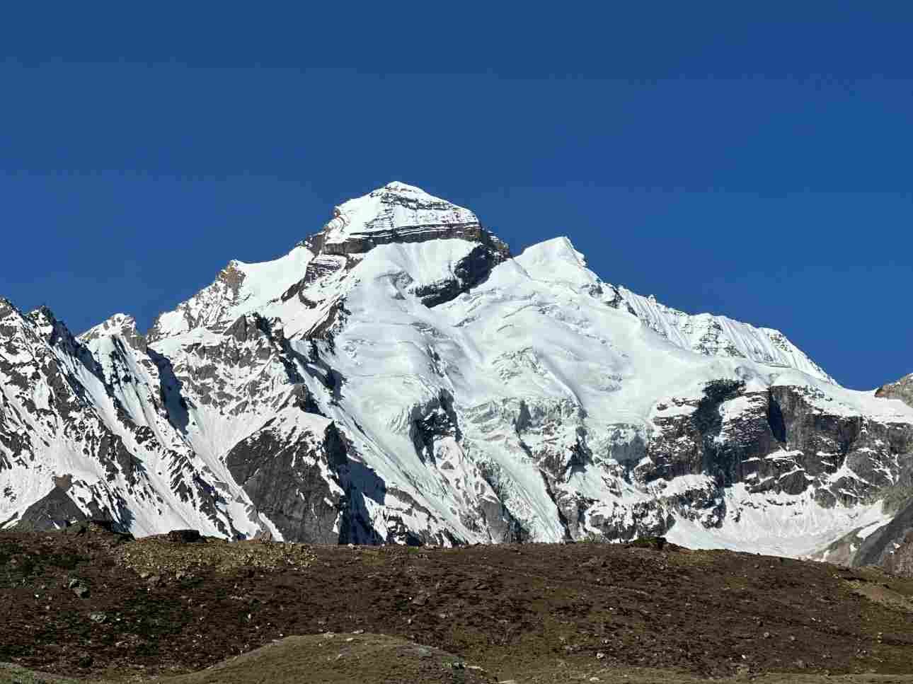
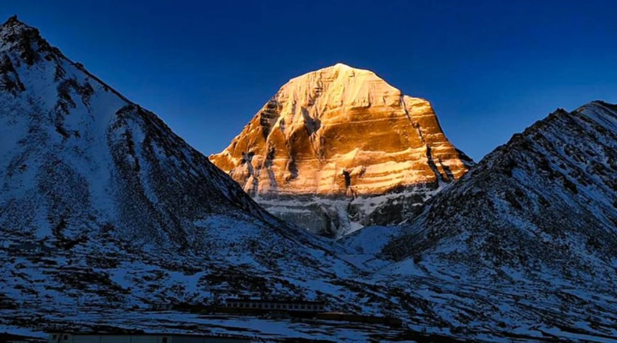
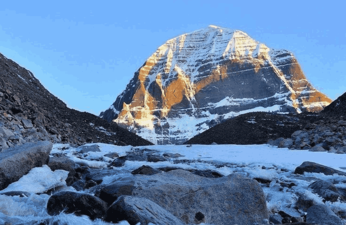
Mount Kailash (6,638 m) and Lake Mansarovar (4,590 m) are located in the Ngari prefecture of
the Tibet Autonomous Region of China — in the far western corner of the Tibetan plateau. The
nearest base town is Darchen, at the southern foot of the mountain, while Purang (Taklakot) —
the main Tibetan road hub — sits approximately 35 km south near the Nepal border.
Every route on the 2026 Kailash Mansarovar route map has two sections: the approach to the
Tibet border, and the Tibet section from the border to the lake and mountain. Once inside Tibet,
all travel is by road in vehicles arranged by a licensed Tibetan tour operator — individual travel
is not permitted in the Ngari prefecture. The 2026 route map has three active entry points:
Lipulekh Pass (India-Tibet, Uttarakhand), Nathu La Pass (India-Tibet, Sikkim), and Hilsa
(Nepal-Tibet border)
The Three Active Routes on the 2026 Kailash Mansarovar
Route Map
Route 1: Uttarakhand Route via Lipulekh Pass (MEA Organised)
Status in 2026: OPEN — 10 batches of 50 pilgrims each. Registration closed 19 May 2026 via
kmy.gov.in. Estimated cost: Rs 2.09 lakh per person.
The Lipulekh route is the oldest and most traditional Indian overland approach to Kailash
Mansarovar — in use since 1981 under the MEA's organised yatra system. It crosses into Tibet
at the Lipulekh Pass (5,334 m) in Uttarakhand's Pithoragarh district. A motorable road built by
the Border Roads Organisation (BRO) now reaches the pass, reducing what was once a
multi-day trek to a largely road-based approach.
Route map stage by stage:
- Stage 1 — Delhi → Dehradun: ~300 km | Road | 5–6 hrs
- Stage 2 — Dehradun → Pithoragarh: ~260 km | Road | 6–7 hrs
- Stage 3 — Pithoragarh → Dharchula: ~90 km | Road | 3–4 hrs
- Stage 4 — Dharchula → Gunji: ~80 km | Mountain road | 3–4 hrs
- Stage 5 — Gunji → Nabhidhang: ~20 km | Road | 1–2 hrs
- Stage 6 — Nabhidhang → Lipulekh Pass (5,334 m): ~8 km | Road (new BRO road) | 1–2hrs
- Stage 7 — Lipulekh → Taklakot/Purang (Tibet): ~18 km | Tibet road | 45 min
- Stage 8 — Taklakot → Lake Mansarovar: ~80–100 km | Tibet road | 2–3 hrs
- Stage 9 — Mansarovar → Darchen (Kailash base): ~30 km | Tibet road | 45 min
- Kora — Darchen → Kailash circumambulation: 52 km | On foot | 3 days
Total duration: approximately 22 days. Delhi to Lake Mansarovar total distance: approximately
1,020 to 1,050 km. Eligibility: Indian citizens aged 18–70, BMI 25 or below, valid passport with
6 months validity beyond September 2026. Foreign nationals and OCI cardholders are not
eligible for the MEA route.

Important 2026 note on Lipulekh:
Nepal formally objected to India's use of Lipulekh Pass for the 2026 yatra in May 2026, citing its
longstanding territorial claim over the Kalapani-Lipulekh area at the tri-junction of India, Nepal,
and China. India's MEA responded that Lipulekh Pass has been a yatra route since 1954 and
that India's position remains consistent. The route is operational for the 2026 season despite
Nepal's objection — but pilgrims should be aware that this territorial dispute is an ongoing
geopolitical issue that could affect future seasons.
Route 2: Sikkim Route via Nathu La Pass (MEA Organised)
Status in 2026: OPEN — 10 batches of 50 pilgrims each. Estimated cost: Rs 3.31 lakh per
person.
The Nathu La route via Sikkim was inaugurated in 2015 as a second official MEA route, offering
a more road-based and less physically demanding alternative to the Lipulekh approach. It was
suspended in 2017 during the Doklam standoff, resumed in 2018, and then closed again from
2020 along with all other routes. It reopened in 2025 and continues in 2026 with 10 batches.
Route map stage by stage :
- Stage 1 — Delhi → Bagdogra (West Bengal): ~1,500 km | Flight (~2 hrs) or train | 2–3 hrs by air
- Stage 2 — Bagdogra → Gangtok (Sikkim): ~125 km | Road | 3–4 hrs
- Stage 3 — Gangtok → Sherathang / 17th Mile (acclimatisation camp): ~35 km | Road | 1–2 hrs
- Stage 4 — Acclimatisation halt: — | Rest days at Sherathang | 4 days mandatory
- Stage 5 — Sherathang → Nathu La Pass (4,310 m) → Tibet: ~18 km | Road | 1–2 hrs
- Stage 6 — Nathu La → Shigatse (Tibet highway): ~320 km | Tibet road | 6–7 hrs
- Stage 7 — Shigatse → Saga → Paryang → Taklakot: ~900 km | Tibet road | 2–3 days
- Stage 8 — Taklakot → Lake Mansarovar: ~55–60 km | Tibet road | 1.5–2 hrs
- Stage 9 — Mansarovar → Darchen: ~30 km | Tibet road | 45 min
- Kora — Darchen → Kailash circumambulation: 52 km | On foot | 3 days

Total duration: approximately 21 days. The Nathu La Pass sits at a lower altitude (4,310 m)
than Lipulekh (5,334 m), which reduces the acute altitude challenge at the border crossing itself
— but the Tibet plateau stages are at similar elevations for both routes. The Nathu La route involves significantly more road travel inside Tibet (the Lhasa Highway route) and is better
suited for older pilgrims and those with limited trekking capacity.
Important: The Nathu La route is more expensive (Rs 3.31 lakh vs Rs 2.09 lakh for Lipulekh)
primarily because the longer Tibet road section involves more vehicle, accommodation, and
guide costs inside China.
Route 3: Nepal Private Route via Simikot–Hilsa (No MEA Quota)
Status in 2026: OPEN — fully operational through private operators. No MEA lottery required.
Available year-round subject to Tibet permit approvals (June–September season).
The Nepal route is the preferred path for Indian pilgrims who do not secure a spot in the MEA
lottery, for international pilgrims of any nationality, and for those wanting a shorter overall
duration. It crosses into Tibet at Hilsa on the Nepal-Tibet border in far-western Nepal. Two
sub-options exist within the Nepal route: the overland trek (Simikot to Hilsa on foot, 4–5 days)
and the helicopter option (Simikot to Hilsa, 30–40 minutes).
Route map stage by stage:
- Stage 1 — Delhi → Kathmandu: ~1,150 km | Flight | 1.5 hrs
- Stage 2 — Kathmandu → Nepalgunj: ~535 km | Domestic flight | 1.5 hrs
- Stage 3 — Nepalgunj → Simikot: ~250 km | Domestic flight | 1 hr
- Stage 4a (overland) — Simikot → Hilsa (Nepal–Tibet border): ~100 km | Trek on foot | 4–5days
- Stage 4b (helicopter) — Simikot → Hilsa: ~100 km | Helicopter | 30–40 min
- Stage 5 — Hilsa → Purang/Taklakot (Tibet): ~30 km | Tibet road | 1 hr
- Stage 6 — Purang → Lake Mansarovar: ~55–60 km | Tibet road | 1.5–2 hrs
- Stage 7 — Mansarovar → Darchen: ~30 km | Tibet road | 45 min
- Kora — Darchen → Kailash circumambulation: 52 km | On foot | 3 days

2026 Kailash Mansarovar Route Map: Complete Status
Summary
| Route | Border Crossing | Managed By | Status (2026) | Duration |
| Uttarakhand (Lipulekh) | Lipulekh Pass (5334 m) | MEA (India) | Open (500 pilgrims) | ~22 days |
| Sikkim (Nathu La) | Nathu La Pass (4310 m) | MEA (India) | Open (500 pilgrims) | ~21 days |
| Nepal (Simikot–Hilsa, road) | Hilsa border | Private operators | Open (no quota) | 14–21 days |
| Nepal (Simikot–Hilsa, heli) | Hilsa border | Private operators | Open (no quota) | 9–14 days |
| 2020–2024 (All routes) | All borders | — | Closed | — |
| 2017 (Nathu La only) | Nathu La | — | Closed | — |
Delhi to Kailash Mansarovar Route Map 2026: Both Options
Delhi remains the primary departure point for all three routes. For the Lipulekh route, the
journey is entirely overland from Delhi to the Tibet border. For the Nathu La route, a short flight
to Bagdogra or a train journey replaces the first leg. For the Nepal route, the Delhi-Kathmandu
flight is the starting point.
Delhi to Mansarovar via Lipulekh Pass: total approximately 1,020–1,050 km | 22 days.
Delhi to Mansarovar via Nathu La Pass: total approximately 2,500+ km by road and Tibet
highway 21 days.
Delhi to Mansarovar via Nepal (overland): total approximately 1,400–1,500 km by air and road 14–21 days.
Delhi to Mansarovar via Nepal (helicopter): approximately 900–1,000 km from Kathmandu 9–14 days.
Lipulekh Pass Map 2026: The Traditional India-Tibet Gateway
The Lipulekh Pass map places this border crossing at 5,334 m on the India-Tibet frontier — at
the tri-junction of India, Nepal, and China in Uttarakhand's Pithoragarh district. It is the oldest
and most historically significant border crossing on the Kailash Mansarovar route map, in use
for the yatra since 1981 and as a trade route for centuries before that.
Key Lipulekh Pass map details for 2026:
- Altitude: 5,334 m above sea level.
- Location: Pithoragarh district, Uttarakhand — tri-junction of India, Nepal, and China.
- Last Indian settlement before the pass: Nabhidhang (approximately 8 km south).
- First Tibet road hub: Taklakot/Purang — approximately 18 km north of the pass.
- New BRO motorable road: now extends from Dharchula all the way to the Lipulekh Pass,
making vehicle access possible for the first time in the yatra's modern history.
- Open season: June to August 2026 (weather-dependent).
- Nepal territorial objection: Nepal claims the Kalapani-Lipulekh area. India maintains its
longstanding position that Lipulekh is Indian territory. The 2026 yatra proceeds via this
route.
Inside Tibet: Key Waypoints on the 2026 Route Map
Once across the Tibet border — at Lipulekh, Nathu La, or Hilsa — all travel is inside the Tibet
Autonomous Region. Individual travel is not permitted. All pilgrims must travel with a licensed
group and a Tibetan guide.
Route-specific Tibet sections:
- Lipulekh route (Tibet section)Lipulekh route (Tibet section)Lipulekh route (Tibet section) km) → Lake Mansarovar
(~80–100 km) → Darchen (30 km). Total inside Tibet: approximately 130–150 km.
- Nathu La route (Tibet section): Nathu La → Shigatse (~320 km) → Saga → Paryang →
Taklakot (~900 km total on Tibet Highway) → Mansarovar (~55–60 km) → Darchen (30
km). This route traverses far more of Tibet.
- Nepal route (Tibet section): Hilsa → Taklakot (30 km) → Mansarovar (~55–60 km) → Darchen
(30 km). Total inside Tibet: approximately 115–120 km.
The Kora — 2026 unchanged:
- Day 1: Darchen → Dira Puk camp (north face) — approximately 19–20 km on foot, 6–7
hours.
- Day 2: Dira Puk → Dolma La Pass (5,630 m) → Dzutrulpuk camp — approximately 22 km,
8–9 hours (hardest day).
- Day 3: Dzutrulpuk → Darchen — approximately 10–11 km, 4–5 hours.
Kailash Mansarovar Yatra 2026: Registration, Eligibility, and
Permits
MEA Route (Lipulekh or Nathu La) — Registration
- Official portal: kmy.gov.in
- Registration deadline: 19 May 2026 (now closed).
- Selection: computer-generated random draw, gender-balanced.
- Confirmation fee: Rs 5,000 non-refundable on selection.
- Eligibility: Indian citizens only, aged 18–70, BMI 25 or below, valid passport with 6 months validity beyond September 2026. Foreign nationals, OCI, and PIO cardholders are NOT eligible.
- Medical requirements: ECG, blood pressure, lung function — tested by ITBP personnel before the yatra begins.
Nepal Route — No Lottery Required
- Book through any licensed Indian or Nepali private tour operator.
- No MEA quota — no lottery required.
- Open to Indian nationals, foreign nationals, OCI cardholders, and international pilgrims of any nationality.
- Tibet Travel Permit and Inner Tibet Permit (Ngari Region) arranged by your operator through Kathmandu.
- Season: June to September 2026.
Conclusion
The 2026 Kailash Mansarovar route map is more complete than it has been in six years. After
five years of closure — years in which COVID-19 and geopolitics conspired to lock the doors
between India and Tibet — three active routes are now open. The MEA routes via Lipulekh
Pass and Nathu La Pass are running under government management. The Nepal private route
runs independently of any government lottery.
The route map itself has not moved. The mountains are in the same place. The border
crossings exist as they always have. What 2020 to 2024 demonstrated is that access to this
pilgrimage is not just a matter of physical fitness or spiritual readiness — it is also a function of
the diplomatic relationship between two nuclear-armed neighbours. When that relationship is
stable, the routes open. When it is not, the route map becomes irrelevant, no matter how well
you have prepared.
For 2026, the routes are open, the permits are being issued, and the mountain is waiting.
Choose your route, prepare your body, secure your documents, and begin.