How to Reach Mansarovar Lake: Complete Kailash Mansarovar Yatra Travel Guide
You have dreamed about it for years. Standing at the shores of one of the most sacred lakes in the world, with Mount Kailash reflected in its still blue waters. But every time you search for information about how to reach Mansarovar Lake, you end up more confused than before. Too many routes. Too many permit requirements. Too much conflicting information online.You are not alone.
Thousands of pilgrims and travelers ask the same question every year. And honestly, the journey to Mansarovar Lake is not the simplest one to plan. But it is absolutely worth every bit of effort. In this guide, we will break everything down in the most simple and practical way possible. Whether you are a spiritual seeker, an adventure traveler, or someone who has always felt drawn to this mystical place, this guide is written just for you.
Where Is Mansarovar Lake Located?
Before planning the route, it helps to understand exactly where Mansarovar is.Mansarovar Lake is situated in the Tibet Autonomous Region of China. It lies near the base of Mount Kailash in the Himalayan range. The lake sits at an elevation of approximately 4,590 meters (15,060 feet) above sea level, making it one of the highest freshwater lakes in the world.Many people ask where is Mansarovar lake in India. The truth is, Mansarovar Lake is not in India. It is in Tibet, which is under Chinese administration. However, it is very close to the Indian border, which is why the journey begins from India and is deeply tied to Indian culture, religion, and spirituality.
If you are wondering where is Manasa Sarovara on a map, it sits in the southwestern part of Tibet, near the Nepal and Indian borders. The nearest major Indian city to begin the yatra is either Dharchula in Uttarakhand or Gangtok in Sikkim, depending on the route you choose.The lake is part of the Himalayas and lies in what geographers describe as a high-altitude plateau. Mansarovar lake location on maps places it at approximately 30.67 degrees North latitude and 81.46 degrees East longitude.
Why Is Mansarovar Lake So Special?
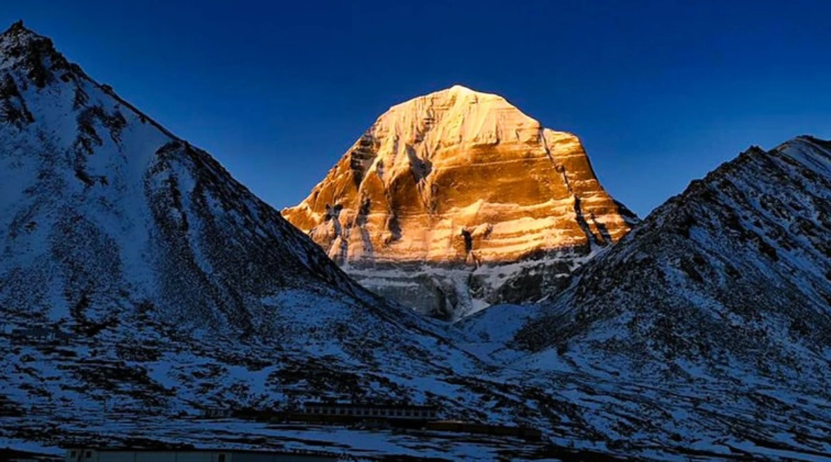
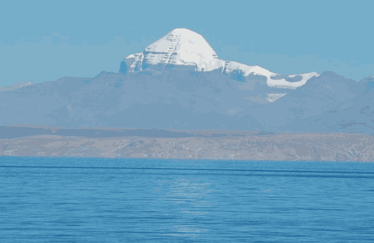
The Mansarovar mystery and its spiritual significance go back thousands of years. In Hindu tradition, the lake is believed to have been created in the mind of Lord Brahma, and its name literally means "Mind Lake" — Manas meaning mind and Sarovar meaning lake.Hindus, Buddhists, Jains, and Bon followers all consider this lake to be among the holiest places on earth. It is believed that taking a dip in the sacred waters cleanses a person of all sins accumulated over many lifetimes.
From a natural perspective,
Mansarovar lake mystery lies in its incredibly clear blue water, the way it changes color throughout the day, and the wild flamingos and bar-headed geese that visit its shores. Even people who are not religious feel something deeply moving when they arrive here. The Mansarovar river, known as the Brahmaputra or Yarlung Tsangpo in Tibet, originates near this region, further adding to the spiritual and ecological importance of this area.
Mansarovar Lake Height and Geography

Mansarovar lake height is 4,590 meters (15,060 feet) above sea level. This is not something to take lightly. At this altitude, the air is thin, the weather is unpredictable, and altitude sickness is a real concern for many travelers.The lake is roughly 88 kilometers in circumference and about 320 square kilometers in area. It is surrounded by snow-capped mountains, and the sight of
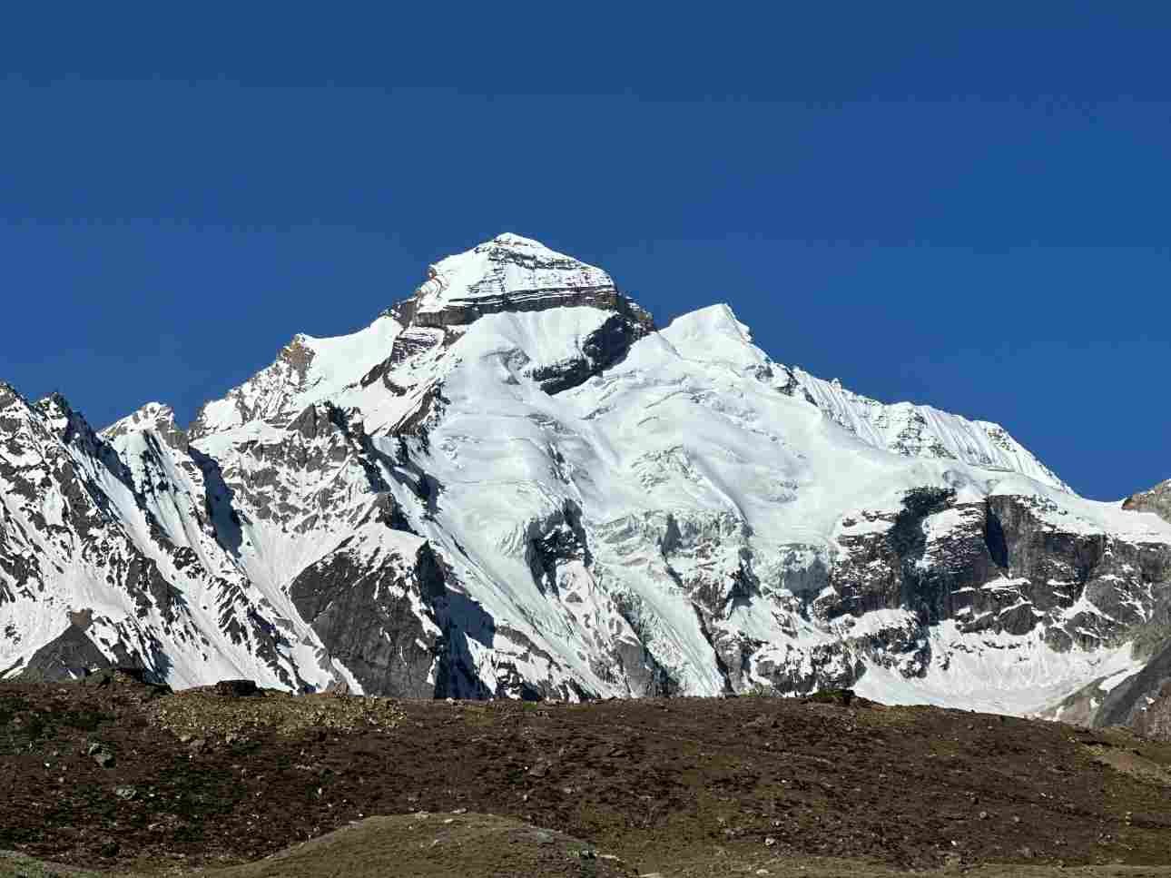
Mount Kailash rising behind it is something that stays with a person forever.Mansarovar lake lies in the Transhimalayan range, specifically in the Gangdise mountain range area. It is one of the highest freshwater lakes in the world and is connected to Rakshastal Lake nearby through a natural channel called Ganga Chu.
How to Reach Mansarovar Lake from India: All Routes Explained
Now let us get into the most important part of this guide. Here are the main ways to reach Mansarovar Lake from India.
Route 1: Via Lipulekh Pass, Uttarakhand (The Traditional Route)
This is the most traditional and historically significant route for the Mansarovar Yatra from India. It passes through the state of Uttarakhand and is organized by the Ministry of External Affairs (MEA) of the Government of India.
Here is how the route unfolds:
- Delhi to Kathgodam or Tanakpur by train or road
- Tanakpur or Kathgodam to Dharchula by road (approximately 220 km)
- Dharchula to Gunji on foot or by vehicle
- Gunji to Kalapani, Nabhidhang, and then crossing the Lipulekh Pass (5,334 meters)
- Entering Tibet and proceeding to Taklakot (Purang)
- Taklakot to Mansarovar Lake
The entire journey from Delhi to Mansarovar Lake via this route takes approximately 24 days. It involves significant trekking through high-altitude terrain, river crossings, and steep mountain paths. This is the most authentic version of the yatra, but it also demands the best physical fitness.
Route 2: Via Nathu La Pass (Sikkim Route)
This is a relatively newer route that was opened in 2015 as part of an agreement between India and China. It passes through the Nathu La Pass in Sikkim and offers a road-based alternative to the traditional trekking route.
The route goes like this:
- Delhi to Gangtok by flight (to Bagdogra Airport) or by train to New Jalpaiguri and then by road
- Gangtok to Nathu La Pass by road
- Crossing into Tibet and proceeding to Shigatse
- Shigatse to Saga
- Saga to Lake Mansarovar
This route is less physically demanding because most of the journey is done by road. It is particularly suitable for older pilgrims or those who are not physically fit enough for long treks. However, rapid altitude gain is still a concern, and acclimatization remains essential. The Nathu La route typically takes around 21 days for Indian pilgrims travelling under the MEA-organized yatra.
Route 3: Via Simikot and Hilsa (Nepal Route)
This is perhaps the most popular route for international travelers and for those who wish to reach Mansarovar Lake without going through the Indian government's official yatra batches. The journey goes like this:
- Fly from Kathmandu (Nepal) to Nepalgunj
- Nepalgunj to Simikot by small aircraft
- Simikot to Hilsa by helicopter or on foot (approximately 2-3 days trekking)
- Cross the border into Tibet at Hilsa
- Drive from Hilsa to Purang (Taklakot)
- Purang to Mansarovar Lake by road
This route is faster — it can be completed in around 12 to 14 days — but it tends to be more expensive due to the flights and helicopter services involved. Many travel operators offer packages through this route for private groups and individual travelers.
Permits and Documentation You Will Need
One of the most critical parts of planning how to reach Mansarovar is sorting out your paperwork well in advance.
For Indian pilgrims via MEA-organized yatra:
- Indian passport (valid for at least six months beyond the travel date)
- Medical fitness certificate from a government-approved hospital
- Registration through the official MEA Kailash Mansarovar Yatra portal
- Chinese Group Visa (arranged by the MEA through the Chinese Embassy)
For travelers via Nepal:
- Valid passport
- Chinese Tibet Travel Permit
- Tibet Entry Permit
- Alien Travel Permit for specific restricted areas
Processing these permits can take time, so start your paperwork at least three to four months before your planned travel date.
Physical Fitness and Health Preparation
- No guide on how to reach Mansarovar would be complete without talking honestly about physical fitness.
- This is a high-altitude journey. The air is thin, the terrain is unforgiving, and the body needs time to adjust. Altitude sickness is real, and it can affect even the fittest of travelers.
- Start training at least three to six months in advance. Regular walking, jogging, and hill climbing will help build the stamina you need.
- Get a thorough medical checkup. Heart conditions, respiratory problems, high blood pressure, and diabetes can all be worsened at high altitude. Your doctor needs to clear you for travel.
- Learn to recognize the signs of altitude sickness. Headache, nausea, dizziness, and difficulty breathing are the early warning signs. Never ignore them.
- Carry essential medicines. Diamox (acetazolamide) is commonly used to prevent altitude sickness, but consult your doctor before taking it.
- Acclimatize properly. Do not rush. Every route has built-in acclimatization stops, and you must respect them even if you feel fine.
Final Thoughts
Reaching Mansarovar Lake is not simply about getting from one place to another. It is about choosing to walk toward something that most people only dream about. Every step of this journey — the winding mountain roads, the thin cold air, the sight of Mount Kailash rising against a deep blue sky — is part of the pilgrimage itself.
Now that you know the routes, the logistics, the permits, and the preparation required, the only thing left is to decide: are you ready to go? Start your planning early, respect the mountain, take care of your health, and trust the process. Mansarovar will take care of the rest.