Amarnath Yatra Walking Distance: Every Kilometre from Every Starting Point
Here is the problem that trips up almost every first-time Amarnath yatri. You search for the walking
distance and you get a number — say, 36 km from Pahalgam, or 14 km from Baltal. And then you
search again and get a different number. Then you find a third number that is different again. By the
time you are done, you have three conflicting figures in your head and no clear picture of what the walk
actually involves. The confusion comes from the fact that different sources count different sections.
Some count from the base camp. Some count from intermediate points like Chandanwari. Some include
only the trek and leave out the road section entirely.
This guide gives you the exact amarnath yatra walking distance from every relevant starting point —
Pahalgam, Baltal, Chandanwari, Jammu, Katra, and Kashmir. Every number is broken down stage by
stage so you know not just the total distance but what each kilometre actually looks like on the ground:
the altitude, the terrain, the time, and what to expect when you get there. Read this once and the
distance question is settled.
Amarnath Yatra Walking Distance: The Direct Answer
Before we go into the detail of every stage and every starting point, here is the direct answer to the core
question. The amarnath yatra walking distance depends on which route you take and where you begin
counting.From Pahalgam — the traditional base camp — the walking distance to the Holy Cave is 36 to 48 km
one way. The variation in that number comes from which sub-route you take through the Pahalgam
approach. The most common route via Chandanwari, Sheshnag, and Panjtarni covers approximately 36
km. The longer traditional route adds additional stages and can reach 48 km. The amarnath yatra
walking distance from Pahalgam round trip — going up and coming back down the same route — is
therefore approximately 72 to 96 km over three to four days.
From Baltal — the shorter base camp — the amarnath yatra walking distance from Baltal is
approximately 14 to 16 km one way. The round trip from Baltal is approximately 28 to 32 km, typically
completed in a single very long and demanding day. Both routes reach the same Holy Cave at 3,888 m.
The walking distance is different. The experience is different. The destination is identical.
Amarnath Yatra Walking Distance: Complete Reference Table
This table captures the amarnath yatra walking distance from every key starting point — from the base
camps to the cave, from Jammu and Katra to the trailhead, and every major stage in between. Use this
as your master reference when planning.
| Starting Point | Destination | Distance | Mode | Approx. Time |
| Pahalgam /
Nunwan | Holy Cave | 36–48 km | On foot | 3–4 days |
| Chandanwari | Holy Cave | ~20–22 km | On foot | 2 days |
| Baltal | Holy Cave | 14–16 km | On foot | 1 day |
| Panjtarni | Holy Cave | ~6 km | On foot / pony | 2–3 hrs |
| Srinagar | Pahalgam Base
Camp | ~96 km | Road | 2.5–3 hrs |
| Srinagar | Baltal Base Camp | ~93 km | Road | 2–2.5 hrs |
| Jammu Tawi | Pahalgam Base
Camp | ~315 km | Road | 6–7 hrs |
| Jammu Tawi | Baltal Base Camp | ~330 km | Road | 8–9 hrs |
| Katra | Pahalgam Base
Camp | ~360 km | Road | 7–8 hrs |
Amarnath Yatra Walking Distance from Pahalgam: Stage by Stage
The amarnath yatra walking distance from pahalgam is the number most pilgrims search for because
Pahalgam is the traditional starting point — the route walked by saints, sages, and millions of devotees
for centuries. The trek begins at Nunwan base camp, just outside Pahalgam town at 2,130 m, and
climbs to the Holy Cave at 3,888 m — a total altitude gain of 1,758 metres spread across four stages
over three to four days.
Stage 1 — Pahalgam to Chandanwari: 16 km
The pahalgam to amarnath distance by foot begins with this first stage — a 16 km walk from Nunwan
camp along the Lidder River valley to Chandanwari at 2,895 m. This is the most approachable stage of
the pahalgam to amarnath trek distance. The trail is wide, well-marked, and graded gently for the first
half before the terrain becomes rockier and more demanding as you approach Chandanwari. Average
walking time is 5 to 6 hours. Ponies are available throughout this stage. Chandanwari has tent
accommodation, food stalls, and medical facilities. Early in the yatra season, a natural snow bridge
across the Lidder River at Chandanwari is one of the most memorable sights of the entire trek.
Stage 2 — Chandanwari to Sheshnag: 13 km
This stage covers the chandanwari to amarnath distance by foot — or more precisely, the distance from
Chandanwari toward the cave, passing through the Pisu Ghati ridge and arriving at Sheshnag Lake at
3,590 m. The 13 km from Chandanwari to Sheshnag is the most scenically dramatic section of the
Pahalgam route and also the most physically demanding up to this point. The Pisu Ghati climb is steep
and sustained. The reward at the top — a panoramic view of the surrounding Himalayan peaks — is
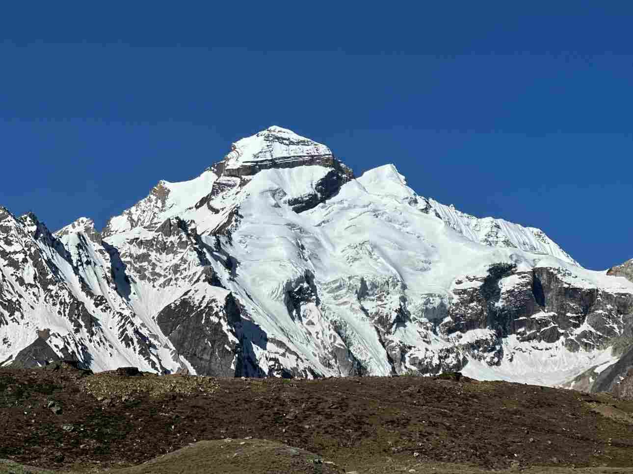
worth every step. The arrival at Sheshnag Lake, a deep glacial blue at 3,590 m, is one of the defining
experiences of the amarnath yatra. Walking time is 5 to 6 hours. Accommodation at Sheshnag is in
fixed-camp tents.
Stage 3 — Sheshnag to Panjtarni: 12 km
The third stage of the pahalgam to amarnath gufa distance takes you from Sheshnag at 3,590 m over
the Mahagunas Pass at 4,600 m — the highest point of the entire yatra — and down to the meadows of
Panjtarni at 3,657 m. This 12 km section is the most altitude-demanding of the Pahalgam amarnath
yatra walking distance. The Mahagunas Pass is crossed at 4,600 m, which is genuinely high — move
slowly, breathe deliberately, and do not underestimate the effect of thin air on your pace and judgment.
The descent from the pass to Panjtarni is long and satisfying. Panjtarni is the helicopter landing point
and the final camp before the cave. Walking time for this stage is 5 to 6 hours.
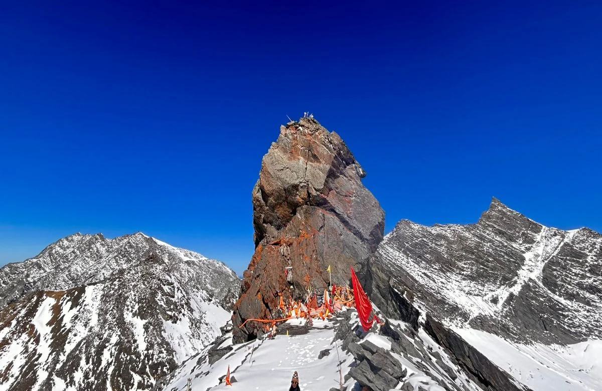
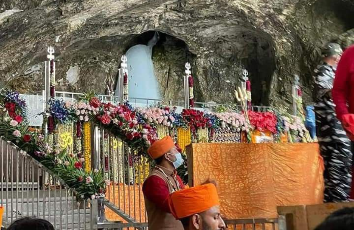
Stage 4 — Panjtarni to the Holy Cave: 6 km
The final 6 km of the pahalgam to amarnath distance by foot is the most emotionally charged section of
the journey. The trail narrows as it enters the gorge leading to the cave, and the sound of devotional
chanting and conch shells builds as you get closer. The Holy Cave sits at 3,888 m — the sacred ice
Shivling inside forms naturally each year and is the reason every pilgrim has made this entire journey.
Darshan queues at the cave can add 30 minutes to several hours depending on the day and season.
Walking time for the Panjtarni to cave section is 2 to 3 hours. Ponies and dandis are available from
Panjtarni for this final stretch.
The total pahalgam to amarnath trek distance one way is therefore: 16 km (Pahalgam to Chandanwari)
+ 13 km (Chandanwari to Sheshnag) + 12 km (Sheshnag to Panjtarni) + 6 km (Panjtarni to cave) = 47
km. Minor route variations and sub-routes can bring this down to approximately 36 km or extend it
slightly beyond 48 km. The round trip pahalgam to amarnath distance by foot is approximately 72 to 96
km over three to four days.

Chandanwari to Amarnath Distance by Foot: Starting Mid-Route
The amarnath yatra walking distance from baltal is the number that attracts pilgrims who have limited
time or want to complete the darshan in a single day. At 14 to 16 km one way, the baltal to amarnath
distance by foot is less than half the Pahalgam route. But shorter amarnath yatra walking distance from
baltal does not mean easier — it means the same altitude gain is compressed into a fraction of the
distance, resulting in a far steeper and more demanding single-day push.
The Baltal base camp sits at 2,743 m. The Holy Cave sits at 3,888 m. The altitude gain over the baltal to
amarnath cave distance is 1,145 metres — gained over 14 to 16 km instead of the 1,758 metres spread
over 36 to 48 km on the Pahalgam route. The gradient is aggressive from the very first step and stays
aggressive throughout. This is not a walk for anyone who has not done any high-altitude trekking
preparation.
Baltal to Domel: 4 km
The first section of the baltal to amarnath distance by foot covers 4 km from the base camp at 2,743 m
to Domel at approximately 2,987 m. The trail enters the narrow gorge immediately after the base camp
and begins climbing steeply along the river. There is no gentle warm-up here. The path is rocky and the
gradient is immediate. Most trekkers cover this section in 1.5 to 2 hours. Domel has a basic halt point
with a medical facility and a tea stall.
Domel to Barari: 4 km
The second section of the baltal to amarnath cave distance covers 4 km from Domel to Barari at
approximately 3,505 m. This is the hardest sustained climbing of the Baltal route. The trail switchbacks
up through rocky terrain with altitude effects building noticeably above 3,000 m. The views of the
surrounding cliffs and the gorge below are dramatic. Walking time from Domel to Barari is approximately
2 to 2.5 hours. There is a medical camp at Barari.
Barari to Sangam: 4 km
From Barari the baltal to amarnath distance continues 4 km to Sangam at 3,657 m — the junction point
where the Baltal trail meets the Pahalgam trail descending from Panjtarni. The gradient eases slightly
after Barari but the accumulated altitude makes breathing noticeably harder. Walking time from Barari to
Sangam is approximately 1.5 to 2 hours. At Sangam, Baltal and Pahalgam pilgrims merge for the final
approach to the cave.
Sangam to the Holy Cave: 2 to 4 km
The final section of the baltal to amarnath cave distance covers 2 to 4 km from Sangam to the cave at
3,888 m. The gradient eases on this final approach as the trail follows the gorge toward the cave
entrance. This section is the most crowded of the Baltal route as pilgrims from both base camps
converge. Walking time is 1 to 1.5 hours from Sangam. The return journey from the cave to Baltal base
camp takes 3 to 4 hours on the descent — significantly faster than the ascent.

Pahalgam vs Baltal: Walking Distance and Altitude at Every Stage
This stage-by-stage breakdown shows the exact amarnath yatra walking distance, altitude, and trek
time at every point on both routes — giving you a complete picture of what your body will encounter on
each day of the journey.
Pahalgam Route
| Stage | Section | Distance | Altitude Range | Time |
| 1 | Pahalgam → Chandanwari | 16 km | 2130 → 2895 m | 5–6 hrs |
| 2 | Chandanwari → Sheshnag | 13 km | 2895 → 3590 m | 5–6 hrs |
| 3 | Sheshnag → Panjtarni | 12 km | 3590 → 4600 → 3657 m | 5–6 hrs |
| 4 | Panjtarni → Holy Cave | 6 km | 3657 → 3888 m | 2–3 hrs |
| Total | Pahalgam → Cave | ~47 km | Gain: ~1758 m | 3–4 days |
Baltal Route
| Stage | Section | Distance | Altitude Range | Time |
| 1 | Baltal → Domel | 4 km | 2743 → 2987 m | 1.5–2 hrs |
| 2 | Domel → Barari | 4 km | 2987 → 3505 m | 2–2.5 hrs |
| 3 | Barari → Sangam | 4 km | 3505 → 3657 m | 1.5–2 hrs |
| 4 | Sangam → Holy Cave | 2–4 km | 3657 → 3888 m | 1–1.5 hrs |
| Total | Baltal → Cave | ~14–16 km | Gain: ~1145 m | 1 long day |
Jammu to Amarnath Distance: The Full Journey from the Railhead
For the majority of pilgrims arriving by train from other parts of India, Jammu Tawi is where the
amarnath yatra practically begins. Understanding the jammu to amarnath distance in full — road and
trek combined — helps you plan your total travel time accurately and avoid the mistake of
underestimating how long the journey from the railway station to the cave actually takes.
The jammu to amarnath distance breaks down into two distinct parts: the road section from Jammu to
the base camp, and the trek section from the base camp to the cave. From Jammu Tawi to Pahalgam
base camp the road distance is approximately 315 km, taking 6 to 7 hours. Adding the 36 to 48 km
amarnath yatra walking distance from pahalgam gives a total jammu to amarnath distance of
approximately 350 to 365 km, spread across four to five days of total travel. From Jammu Tawi to Baltal
base camp the road is approximately 330 km, taking 8 to 9 hours. Adding the 14 to 16 km baltal to
amarnath cave distance gives a total jammu to amarnath distance via Baltal of approximately 344 to 346
km — shorter in total distance but compressed into two days of travel.
Most pilgrims arriving at Jammu Tawi by overnight train plan for an overnight stay in Jammu before the
long road journey to the base camp. This is good practice — it breaks the journey into manageable
segments and gives you one additional night of low-altitude rest before the altitude climbing begins.
Jammu sits at just 327 m above sea level, so it is not an acclimatisation stop in the strict sense, but the
additional rest day genuinely helps.
Kashmir to Amarnath Distance: From Srinagar to the Holy Cave
When people search for the kashmir to amarnath distance, they are typically asking about the road
distance from Srinagar — the capital and main city of the Kashmir valley — to the Amarnath base
camps, and then the walking distance from there to the cave. Srinagar is the nearest major city with an
international airport to the amarnath yatra, and it is where most pilgrims arriving by flight begin the road
section of their journey.
From Srinagar, the road distance to Pahalgam base camp is approximately 96 km via the Anantnag
highway — a journey of 2.5 to 3 hours. Combined with the 36 to 48 km amarnath yatra walking distance
from pahalgam, the total kashmir to amarnath distance via the Pahalgam route is approximately 132 to
144 km. Via the Baltal route, the road distance from Srinagar to Baltal is approximately 93 km taking 2
to 2.5 hours. Combined with the 14 to 16 km baltal to amarnath distance by foot, the total kashmir to
amarnath distance via Baltal is approximately 107 to 109 km.
Most pilgrims flying into Srinagar spend at least one night in the city before heading to the base camps.
This is worth doing both for acclimatisation — Srinagar at 1,585 m is a useful intermediate altitude stop
— and because Srinagar itself is one of the most beautiful cities in India. A morning on a shikara on Dal
Lake before the yatra begins is the kind of memory that frames the entire journey.
Katra to Amarnath Distance: Combining Two Great Pilgrimages
Katra — the base town for the Vaishno Devi yatra in Jammu — is a significant starting point for pilgrims
who combine the Vaishno Devi darshan with the Amarnath yatra in a single trip. The katra to amarnath
distance is longer than the direct Jammu to Amarnath journey because Katra sits approximately 48 km
south-east of Jammu on a different road.
From Katra to Pahalgam base camp, the road distance is approximately 355 to 360 km via Jammu —
taking 7 to 8 hours by road. Adding the pahalgam to amarnath trek distance of 36 to 48 km gives a total
katra to amarnath distance via the Pahalgam route of approximately 390 to 410 km, spread across five
to six days of total travel including the Vaishno Devi yatra itself. From Katra to Baltal via Jammu and
Srinagar the road distance is approximately 370 to 375 km, taking 8 to 9 hours. Adding the baltal to
amarnath cave distance of 14 to 16 km gives a total katra to amarnath distance via Baltal of
approximately 385 to 390 km.
Many pilgrims structure this as a 10 to 12 day combined yatra package: fly or travel by train to Katra,
complete the Vaishno Devi trek (13 km from Katra to Bhawan and back), rest for a day, drive to the
Amarnath base camp, complete the amarnath yatra walking distance, and return to Jammu for the
journey home.
What Actually Affects Your Walking Distance Experience
The amarnath yatra walking distance numbers are fixed — the trail does not change from year to year.
But what changes dramatically is how those kilometres feel to different people. Understanding the
factors that affect your walking distance experience helps you prepare specifically rather than
generically.
Altitude Is Not the Same as Distance
The most important thing to understand about the amarnath yatra walking distance is that altitude
changes everything. A flat 5 km walk at sea level takes most adults about an hour. A 5 km climb at
3,500 m with a 400 m elevation gain can take 2.5 to 3 hours for the same person. This is why the
pahalgam to amarnath distance by foot of 36 to 48 km takes three to four days even though, on flat
ground, that distance could theoretically be walked in a single long day. The altitude forces you to slow
down whether you want to or not. The ones who fight this reality are the ones who develop altitude
sickness.
Crowd Density on the Trail
On peak yatra days — particularly around Shravan Purnima and during the first and last weeks of the
season — the trail becomes extremely crowded near the cave approach. This adds significant time to
the final 6 km of both routes. Pilgrims who time their amarnath yatra walking distance carefully —
arriving at the cave in the early morning hours rather than mid-morning — generally have a smoother
darshan experience and a faster overall journey time.
Weather and Trail Conditions
Rain is the most common weather disruption on both routes. The stone trails of the Pahalgam route and
the rocky paths of the Baltal route both become slippery and slower when wet. The Mahagunas Pass
section on the Pahalgam route can be particularly treacherous in rain. Budget extra time on any day
where rain is forecast. SASB sometimes temporarily suspends movement on sections of both routes
during bad weather — carry a rain jacket and be prepared for unexpected halts.
Tips to Manage the Walking Distance Well
- Start every trekking day by 5 to 6 AM — the early hours have the best weather, the coolest
temperatures, and the least crowd on the trail.
- Take the Pahalgam route if this is your first high-altitude trek — the gradual amarnath yatra walking
distance from pahalgam spread over three days is far kinder to your body than the Baltal route's
single brutal push.
- If you are taking the Baltal route, leave the base camp no later than 4 to 5 AM to ensure you
complete the darshan and return before dark.
- Use trekking poles on both routes — they reduce knee stress on the descents by up to 30 percent
and genuinely make the downhill sections of the baltal to amarnath distance by foot safer.
- Hire a pony for the Panjtarni to Holy Cave section if your energy is flagging — these 6 km are flat
enough that most pilgrims walk them, but if you have pushed hard through the Mahagunas Pass
section, pony support for this final stretch is sensible.
- Acclimatise for at least one night at your base camp altitude before beginning the trek — altitude
sickness on day one of the walk is the most common reason pilgrims have to turn back.
Conclusion
The amarnath yatra walking distance is not one number — it is a set of distances that together describe
a complete journey. The 16 km from Pahalgam to Chandanwari. The 13 km from Chandanwari to
Sheshnag. The 12 km over the Mahagunas Pass to Panjtarni. The final 6 km to the cave. Or if you take
the Baltal route — 14 steep and unrelenting kilometres from the base camp to the same sacred
destination.
Every one of those kilometres means something different on the ground than it does on paper. The
distance from Sheshnag Lake to the Mahagunas Pass is 12 km on the route map. In the body of a
pilgrim crossing it at 4,000 m, it is something else entirely. Know your amarnath yatra walking distance
before you go. Train for it seriously. Choose your route honestly based on your fitness and time. And
when you finally stand inside that cave at 3,888 m, breathless from altitude and devotion in equal
measure, every single kilometre of the journey will have been worth it.